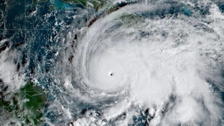
Meteorologists at the National Hurricane Center have just confirmed that Hurricane Melissa has reached category five. According to the NHC, the storm data shows sustained winds of 175 miles per hour and a low central pressure of ~901 mb. It will mostly impact Jamaica (where it will land anytime now) and Cuba (Granma, Santiago de Cuba, and Guantanamo). Apart from being a Category 5, Melissa moves slowly… meaning that any place it arrives, it will leave devastation for hours or days.
The Fury of Category 5
The Saffir-Simpson Scale is a kind of traffic light for hurricane danger. Category 5 is the “Maximum Destruction Level,” with winds exceeding 155 mph. This is not a strong gale, but rather like a freight train blowing constantly, like the big bad wolf blowing on the straw house. Weak structures and mobile homes collapse completely. Even well-built buildings can suffer serious structural damage. To make matters worse, Hurricane Melissa is moving at a speed of only two to five km/h, which makes it almost stationary.
This has experts exceptionally concerned, since if the storm moves at a snail’s pace, this area will receive rain and wind not for hours, but for a day or more, multiplying the damage exponentially. Hurricane Melissa went from a tropical storm to a category five hurricane in less than 48 hours. This was due to the warm waters of the Caribbean, which are 2-3°C above normal temperatures.
The Forecast for Hurricane Melissa
To track these meteorological titans, experts use “Spaghetti Models.” These are computer simulations that predict the route. These models expect the storm to make direct or very close landfall in Jamaica in the coming hours today. The eye of the storm will then head toward Cuba on Wednesday. Finally, the system will look toward the Bahamas and the Turks and Caicos Islands starting Thursday, before accelerating toward the open Atlantic.
All models indicate that the continental United States is safe from a direct hit if Hurricane Melissa follows its current trajectory.
Although the 175 mph winds are concerning, flooding due to the hurricane’s slow movement is what worries experts the most. Jamaica is forecast to receive 15 to 30 inches of rain, with local maximums that could reach 40 inches in higher areas. This will cause massive flooding and river swells. Soil saturation will cause numerous landslides and mudslides in mountainous regions.
The third danger is a storm surge, in which seawater is pushed by the wind toward the coast. This type of storm surge is expected to reach 9 to 13 feet above ground level along Jamaica’s southern coast. The total flooding of low-lying coastal areas (including parts of Port Royal and Kingston) has classified them as non-survivable areas.
Precautions and Evacuation
The Prime Minister of Jamaica has officially declared the state of emergency.If you are under mandatory evacuation orders, you must leave now. The Jamaican and Cuban authorities have activated mass evacuation plans and have set up hundreds of shelters. Go to an official shelter or a sturdy house on high ground immediately. If you are in a safe structure and have been instructed to stay at home, remain in the safest interior room away from windows.
Ensure you have your Go-Bag ready with your documents (ID, insurance) in waterproof bags. Also include a flashlight, a battery-powered radio with extra batteries, and all your vital medication. Have plenty of bottles of drinking water available, as the supply could be cut off. If the weather suddenly calms down, do not be complacent; it is likely to be the eye of the hurricane, and the fiercest winds will return immediately from the opposite direction. Make sure to prepare and stay alert!

