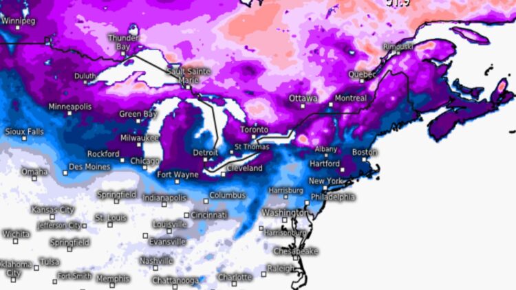
The United States is facing a storm unlike any seen in a long time. The National Weather Service has confirmed a blast of Arctic air that will pass through several states, urging residents to take extra precautions. The imminent, prolonged cold wave and the possibility of snowstorms over the weekend are the main topics of conversation on the streets. The polar vortex alert in the United States means temperatures could drop as low as 10 to 20 degrees Fahrenheit.
The National Weather Service noted that the cold has returned east of the Mississippi River
Citizens of the United States should prepare for a blast of frigid Arctic air passing through various regions, as meteorologists have been warning in recent hours. Experts say the most important aspect of all this is safety. Any preparations citizens routinely make for prolonged periods of cold weather are advisable, especially given the possibility of a major snowstorm and freezing temperatures arriving in the coming hours. The National Weather Service noted that the cold has returned east of the Mississippi River, a situation that has caused snowmelt in the Ohio Valley and is already creating difficulties, as has been seen in Michigan.
The negative NAO appears to persist throughout the rest of January and February
To be precise, the National Weather Service explains that the term “vortex” refers to the counterclockwise rotation that keeps cold air near the poles. “While this cold front isn’t expected to set any records, it will feel much colder across much of the eastern U.S. as daytime highs drop 10 to 20 degrees across the country under Arctic high pressure,” specialists said. The North American Oscillation (NAO) is a teleconnection measure that indicates whether there is a ridge or a trough over Greenland. According to this measure, a negative NAO (a ridge over Greenland) slows down snowstorms, increasing their impact on the eastern United States; precisely, this weekend this region of the country will experience a negative NAO. However, the negative NAO appears to persist throughout the rest of January and February, further reinforcing our colder weather pattern and preventing any storms that form from moving quickly out of the area, as explained by New Jersey Weather.
There are records of extreme cold waves occurred in January 2014, or the historic ones of 1977, 1982, 1985, and 1989
There are several things the polar vortex is not, as explained by the National Weather Service. The term “polar vortex” has recently become popular, drawing attention to a meteorological feature that has always been present; moreover, polar vortices are not a new phenomenon, despite the fact that we’ve been hearing this term a lot lately. In this specific case, there are records of extreme cold waves, such as the one that occurred in January 2014, or the historic ones of 1977, 1982, 1985, and 1989. In any case, as experts point out, this meteorological phenomenon should not alarm people, but rather serve as a warning.
The streets become slippery due to the ice created by the low temperatures, which can be dangerous for everyone
Regarding recommendations, authorities are urging everyone to take extra precautions, especially the elderly. For example, they recommend going to the supermarket and buying only essential items to avoid going out during the cold snap. The streets become slippery due to the ice created by the low temperatures, which can be dangerous for everyone. Likewise, authorities recommend driving only if absolutely necessary, as icy patches on the roads can be treacherous, particularly in areas where residents are not accustomed to this type of weather. In any case, and if you have any questions, consult official government websites.

